
Alder Creek, Trail Creek, and Christensen Fire Updates 08/31/2021
- Aug 31, 2021
- 3 min read
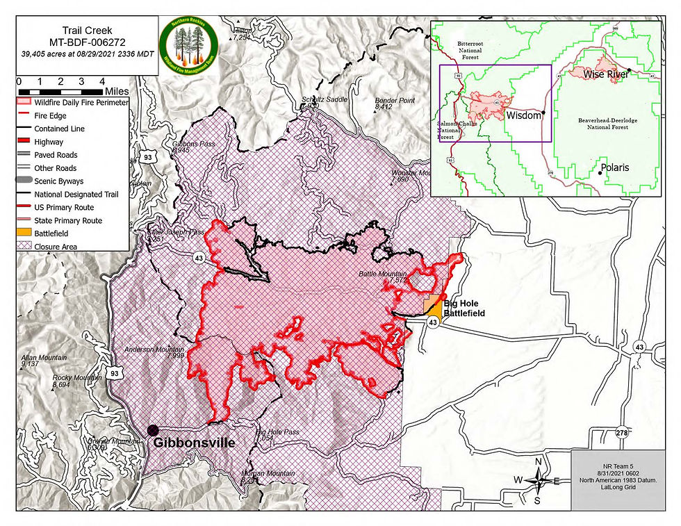
TRAIL CREEK
Location: 20 miles West of Wisdom
Star t date: July 8, 2021
Size: 39,405 acres (IR mapping-8/30)
Percent Complete: 58%
Cause: Lightning
Total personnel: 218
TRAIL CREEK FIRE:
The fire continues to be active in the Three Mile Creek, Nez Perce, and Salix Creek areas. While the areas are experiencing an increase in activity, the majority of growth is interior
to the fire and not increasing in acreage outside the fire perimeter. Helicopters will be
available to assist ground crew with buckets drops as needed. Crews are beginning the
process of removing excess water-handling equipment on the Highway 93 corridor. They
will work southward along Highway 93 but leave all water-handling equipment in tact in
Gibbonsville. Crews continue to implement the suppression repair plan, in consultation
with agency resource advisors. National Guard crews are assisting with logistics and
suppression repair operations until tomorrow.

ALDER CREEK
Location: 7 miles west of Wise River
Star t date: July 8, 2021
Size: 14,158 acres (IR mapping-8/30)
Percent Complete: 24%
Cause: Lightning
Total personnel: 176
ALDER CREEK FIRE:
Fire activity in the Teddy Creek area picked up in the evening hours, with visible flame
and smoke observed. This activity is interior to the perimeter and does not cause concern
or threat to the line. Firefighters continue to backhaul excess water-handling equipment
along the Pioneer Scenic Byway, monitor areas of heat on the fire, and implement
suppression repair. On the west side of the Pioneer Scenic Byway, heavy equipment will
work on suppression repair. Crews continue to monitor the large fuels smoldering in the
interior of the fire; no significant fire growth is expected.

CHRISTENSEN
Location:12 miles west of Wise River
Star t date: July 16, 2021
Size: 11,161 acres (IR mapping-8/30)
Percent Complete: 20%
Cause: Lightning
Total personnel: 12
CHRISTENSEN FIRE:
Heavy equipment completed road repairs on Calvert Road Loop and removed all but six
water pumps from the Bryant Creek area. Scattered heat and visible smoke remains in the
Trident Peak area, where pockets of fuel continue to burn out within the perimeter. The
fire is expected to continue slowly backing into Bryant Creek under current conditions.

TODAY'S WEATHER/FIRE BEHAVIOR:
Drift smoke from others fires in the region may provide some shading in the morning
hours. Temperatures are expected to be in the upper 70s with relative humidity in the
mid-teens. Today's warm and dry conditions will be similar to yesterday, with winds
picking up earlier and gusting stronger. Sustained winds of 10-15 mph are expected
starting at about 11am with gusts to 25 mph and even 30 mph in the Trident Peak area.
Another night of poor relative humidity recovery will result in an earlier and longer burn
period. The Three Mile Creek area continues to be the most active portion of the fire.
Isolated tree torching and short uphill runs are expected in the Three Mile Creek area,
Bryant Creek area and Trident Peak area. Fire behavior analysts do not expect movement
of the fire to the west, given the steep terrain and predicted winds.
The effects of the southwest winds vary by elevation and aspect. Areas with scattered heat
in Salix Creek, Gory Creek, and Teddy Creek continue to burn out heavy fuels in the
fires' interiors. These areas are sheltered from the winds and should burn back onto
already burned portions of the fire. The fire is having a hard time becoming established
enough to move around; no significant fire growth is expected.

SAFETY:
Highway 43 and the Pioneer Scenic Byway are open to through traffic. Slow down and
stay alert for firefighting equipment and vehicles, smoke, and downed trees. Motorists
should also watch for bicyclists, hikers, and vehicles operating at slower speeds.
FIRE RESTRICTIONS:
Public lands in southwest Montana and central Idaho are in varying stages of fire
restrictions. Check mtfireinfo.org and idahofireinfo.com for the latest information.
CLOSURES:
Portions of the Continental Divide Trail remain closed.
The Big Hole National Battlefield is closed until further notice.
May Creek Campground is closed.
Closure orders remain in effect on the Beaverhead-Deerlodge and Salmon-Challis
National Forests. Forest officials are currently modifying closures boundaries.


Comments